Whangārei's Bush Walks, Waterfalls and Stunning Vistas
There’s no better way to spend the day than exploring the natural beauty of Northland. These walks take you through native bush, past historical Māori pā sites and waterfalls, and onto secluded beaches with picture-perfect views you won’t want to miss.
Parihaka
Parihaka Scenic Reserve is the largest pā site in the country. At the summit, there is a viewing platform with expansive views over the city and harbour, and a memorial to those who lost their lives in World War II. There are three walking tracks that link up through the reserve, all steep climbs but well worth the effort!
Mount Manaia
Sacred to the Māori, Mount Manaia was created during volcanic action. The views from the summit are spectacular and well worth the many steps you’ll have to climb to get up there. Expect to spend about two hours both ways – you may even want to pack a small picnic to sit back and enjoy the magnificent views from the top.
Mount Aubrey
If you still have some energy after your Mount Manaia climb, another ancient volcano with panoramic views is just down the road. The northern end of the Mount Aubrey track starts at Tiller Park (just off Reotahi Road), and the southern end is accessed near Little Munro Bay accessed by Bay View Road. Another stunning climb, with views for miles on a clear day.
Pukenui Forest
The Pukenui Forest Loop track is a beautiful escape into the natural environment and will take just over three hours. For more experienced trampers, you have the option to branch off to the Main Ridge Track or the Taraire Ridge Loop Track for a longer, more challenging walk with steep climbs.
From the Main Ridge Track, you can access Barge Park, the Quarry Gardens and the Coronation Scenic Reserve which is home to North Island brown kiwi and nikau groves, includes Māori pā sites and views out over Whangārei Harbour.
Otuihau Whangārei Falls
Extend your walk from A H Reid Memorial Park, over the swinging bridge, and along to this 26-metre high cascading waterfall. For a shorter walk, park at the carpark on Boundary Road and complete the 30 minute loop walk. You can also reach the Otuihau Whangārei Falls from the Hātea River Walkway.
Bream Head
Considered as wahi tapu (a sacred place) by Māori, and a North Island brown kiwi sanctuary, this area is tended by the local community, local iwi and the Bream Head Conservation Trust. The 700-year-old Te Whara Track stretches between Ocean Beach and Urquharts Bay, and a shorter loop from Urquharts Bay to Smuggler’s Cove will take you past a World War II gun emplacement.
A H Reid Memorial Park
A H Reid Memorial Park has several loop walks to explore, through stunning native bush, along riverbeds and through treetops. We recommend starting at the Whareora Road carpark and joining onto the Alexander Walk. From here you’ll merge onto the Canopy Walk and walk among the treetops on a raised wooden canopy among beautiful large kauri trees. Continue onto the McKinnon Track which leads to the Paranui Falls and stunning lookouts, before looping back to the carpark via Elizabeth Path.
Hātea River Walkway
The walkway starts along the Whangārei Aquatic Centre carpark on Riverside Drive. Follow it along Hātea River to a boardwalk through mangroves, then through native bush to A H Reid Memorial Park where you’ll follow signs for the Elizabeth Track and Hātea Walkway. Continue along the river past farmlands and over a swinging bridge to Otuihau Whangārei Falls. This walk takes two hours each way, so we recommend packing plenty of water and a picnic to enjoy at the base of the waterfall.
Matapouri / Whale Bay Loop
Start at the north end of Matapouri Beach and take the Matapouri Headland Track. At the halfway point, break right and take the 20 minute bush track down to the white sands at Whale Bay for a refreshing swim. You can complete the loop back to Matapouri via the Morrison Reserve Track or Ridge Track.
Port Nikau News
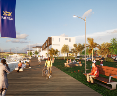
Port Nikau: A Waterfront Community in the Heart of the City
The future of residential development looks vastly different to that of 10 or even 20 years ago. The days of the quarter acre residential section are evolving, as access to land becomes more difficult and people are choosing to live in more sustainable, connected communities where resources, such as green spaces, can be shared, rather …
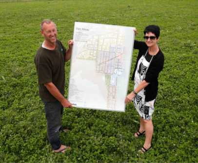
Port Nikau Masterplan with Construkt
Urban planning company Construkt has partnered with Reyburn & Bryant to perfect and produce a Masterplan for the new Port Nikau development, which the Whangārei District Council has given the go-ahead. The plan will eventually provide over 1,200 homes adjacent to a harbour-side town centre, in the 67ha of former port land to create genuine …
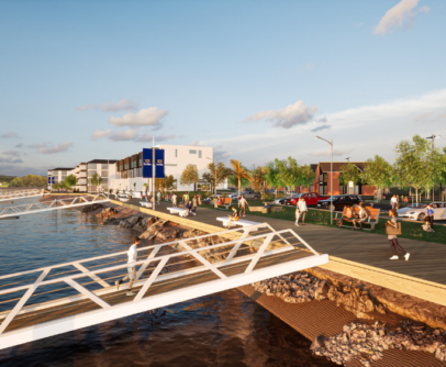
Port Nikau to be transformed
Plans are in progress for a massive 88-hectare development in Whangārei, including the construction of more than 500 homes to cater for the region’s population boom. The Whangarei District Council last year approved the Port Nikau Environment Master Plan submitted by Port Nikau Joint Venture Partners, co-owned by Tony and Clare Davies-Colley. After the first …